Thursday, March 30, 2017

Exploring New Sand at the Eureka Dunes

Eureka Dunes


Date: November 24, 2016
Place: Eureka Dunes, Death Valley National Park
Coordinates: 37.11377, -117.68100

Distance: 0.7 miles
Level: Strenuous

After the disaster that met Pappa Quail's camera at the Mormon Rocks we needed to get a new one. We were very fortunate to find a store that was still open in Phelan so late in the day. They only had a lens replacement, however, so I suggested to get a cheap and simple 'Point n' Shoot' pocket camera for the broad angle shots. In the end we bought the replacement zoom lens and Pappa Quail attached it to my camera, and I used the simple pocket camera for the remaining days of our road trip.
It turned out a very useful arrangement: the pocket camera yielded quite decent quality photos. Not up to notch like the one I lended Pappa Quail, but on the other hand it was much lighter and quicker, and I was not as stressed about it banging against rocks.
We managed to get to Ridgecrest that evening and had passed the night in a hotel there, and first thing in the morning we were headed toward Death Valley National Park. Sacrificing that day's hiking time, we made it right away to Mesquite Springs campground to find a spot. Mesquite Springs is a lovely, and quite desolate campground. It is the first campground we've ever camped at in Death Valley NP, when still a young couple sans chikas. It is a non-reservable campground, and it being Thanksgiving time, I was worried about not finding a place and having to camp in the wilderness. (Not that I mind wilderness camping, but on this occasion we preferred having the usual comforts of an established campground).
We were right to hurry to the campground. There were only 4 sites available when we arrived and by the time our tent was pitched the campground was full. When we were done setting camp and eating lunch, however, is was already afternoon and the day was growing short.
Pappa Quail gulped when I told him I wanted to go see the Eureka Dunes. Apparently, the dunes nearly two hours drive away from our campground. We went anyway, willing to drive back in darkness.
The Eureka Dunes are located in the south corner of Eureka Valley in the northwest part of Death Valley NP. To get there from the main park area where we needed to drive north on Death Valley Road, a long dirt road that leads to the north tip of the park and passes the Last Chance mountain range westward, leading out of the park toward the town of Big Pine.

Endless dirt road northward. 
It was a very lonely drive. We saw one car parked on the side of the road and along our drive we passed maybe two other cars. These were all who ventured north of the main park region.
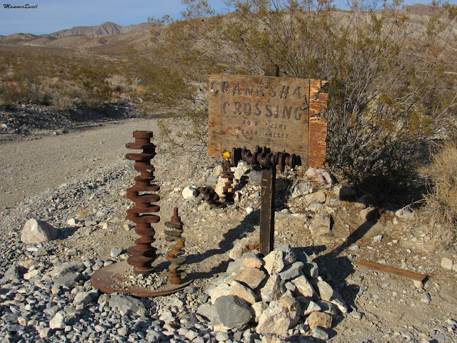
The road splits at the Crankshaft Intersection and we stopped there momentarily before taking the Death Valley Road northwest toward Big Pine. I had to take in the scenery there. The vastness of the desert, the raw power of the sharp-angled mountains, near naked of vegetation.
I also had to photograph the interesting display at the intersection.  All made of ... crankshafts.


We continued across the Last Chance mountain range and past a small gold mine, abandoned of course. We descended into Eureka Valley and the road was straight and level once more. Just before exiting the park we took a left (southward) turn to the dunes.
The Eureka Dunes, the tallest sand dunes in California, were quite visible from the Death Valley Rd, about 10 miles away.
Eureka Valley and Dunes. 
Pappa Quail was driving and I was hungrily swallowing the view. Every now and then I asked him to stop so I could step out of the car and snap a few shots. All of these mountains deserve having their image displayed. I chose this one below.
"Last Chance" 
The mountains tower over the Eureka Dunes, dwarfing them. It was only when we approached that we understood how large they truly are.
Eureka Dunes
There's a small, primitive, and very run down campground at the foot of the dunes. I had this campground in my mind as a backup in case we couldn't find space at Mesquite Springs. When we arrived there, however, I was thankful for not having to stay there. I would have loved the isolation of the place, but everything else about this campground depressed me, as its few amenities were broken and soiled, the ground littered, and the single stall pit toilet in a disgusting state. It's unlock able door bore an angry note of a park ranger fuming over campers dumping trash into the toilet pit (a big no-no. Don't ever do that). In short, I'd rather have gone wilderness camping if that was the only established option.
A creosote (Larrea tridentata) bush at the dune's foot. 
The few campsites appeared occupied. Other cars were parked together a bit further away. We left the car near the campground and started toward the dunes. We had arrived there too late to make it to the summit, but still had a good hour of daylight to explore the dunes.
Our hike as captured by Pappa Quail's GPS
Going up a tall sand dune isn't easy. For each two steps you take, you sink one back. We found the tracks of previous hikers and followed in their footsteps, using their deep footprints as 'steps'. Still, it was a slow work uphill.
Going up
Taking frequent breathers along the way I stopped and looked around. One of the things I like about the desert is the visible geology, naked and unhidden beneath alluvial soil and vegetation.
Last Chance
The Last Chance mountains are of sedimentary rocks, limestone and geological relatives. The colorful rock layers marked the eras in which this place was submerged under water. Now one of the driest places in California, it is hard to believe this place was ever submerged.
I caught up with Pappa Quail and asked him to take a zoomed-in photo of the rock layers.
Last Chance - zoomed
An expert geologist may be able to count the number of geological eras by the visible rock layers, as a dendrologist counts tree rings. I am expert on neither so I just enjoyed the view east and then turned my gaze to the north. 
There, below me, lay the vast Eureka Valley, flat and arid. A white evaporation flat stretched to the west and a small column of dust marked the progress of a sole car in the distance. 
Eureka Valley
We continued along the dune's ridgeline. The wind was picking up and a sheet of sand flowed over the dune face. On the lee side the sand was settled in ripples, some ridged with dark grains. more dark sand had 'puddled' at he bottom of the concave vales between the dune ridges. Everything was on the move.
Ripples
We arrived at the summit of the first dune and the chikas decided they'd had enough and wanted to stay there and play in the sand. Pappa Quail remained with them while I went forward a little bit further. There was no going to the highest peak that day, but I did want to get a bit wider view.
Eureka Dunes
Eventually I too had to turn around and go back. I said goodbye to the high dunes, silently promising to make better timing plans for my next visit there. 
Ridgeline
On my way back I witnessed the first sunset. I stood at the perfect spot to see the sun disappear behind the peak of a nearby dune. 
First Sunset
A few steps away, however, and I was back in the realm of daytime, if only for a short while.
Creeping darkness
From there on I was hopping between night and day as I made my way back to my family and down the dune.
And with each step night was gaining.
Night and Day
And then the sun disappeared completely, this time behind the Inyo Mountains on the west.
There was still enough light to make it back to the car. And also to photograph some more. It turned out that my simple pocket camera had good light sensitivity.
I balanced on the ridge of the dune and progressed forward in large hops. Occasionally I looked down - it was a steep slope, and being made of sand - a very inviting slope. It was not in my desired direction, though.
Slide
After reuniting with my family we split again - Pappa Quail and the chikas took the shortcut down to the campground: the chikas rolled and Pappa Quail run down the slope. I waited behind for some time, unwilling to leave this place, but eventually I too started down the steep slope.
Last Sun
I tried butt-sliding, and failed miserably. Sand isn't snow - it is sticky. I had to paddle with my hands and feet to make it down a grade I would have had zoomed through if it was snow-covered.
But the slow, hard-working descent had its bonuses, because I had the time to stop and look at the pale plants that grew at the lower part of the slope. One of them was this interesting shrub:
Desert Dicoria, Dicoria canescens

The further down I went, the further the rest of my family got. I stopped to look at this strange-looking grass that turned out to be quite rare and endemic to the Eureka Dunes area and when I raised my eyes from the plant I saw that Pappa Quail and the chika were already near the car.
Eureka Dunegrass, Swallenia alexandrae
The post sunset daylight was disappearing fast. These last images only look bright because of the camera's sensor adjustment, but in fact these photos were taken under low light conditions. Including this beetle that crossed my path to the car.

The wind was blowing hard now, and when I made it back to the Eureka Dunes Campground the chikas and their father were already tucked inside the car, safe from the grind of the airborne sand. I took one last snapshot of the Last Chance Range in the last of that day's light and got in the car.
Last Chance in the last light
It was a very dark drive back to Mesquite Springs Campground, and very windy and cold when we got out of the car. Without delay we built a campfire and cooked dinner, after which the chikas and Pappa Quail went inside the tent.
I remained outside to clean up and enjoy the desert silence. I also had a little surprise to prepare. Just before going on this road trip I invested in my very first dutch oven and I wished to surprise my family with a campfire peach cobbler in the morning.
I mixed the ingredients and tried my best to maneuver the heavy iron pot on the glowing coals. Then I sat back and looked at the heavens.
It was a no moon night and as I had hoped for - clear skies with a spread of stars that can no longer be seen anywhere near the Bay Area. It was absolutely spectacular.
I felt the urge to document the starry night, but sadly, I have not the proper equipment for night photography. I switched the lenses on my old camera to the wide angle, and went for a walk around the campground. But even the more sophisticated camera didn't work. After much manipulations and frustration I managed to snap a single shot, then gave up and resumed my quiet enjoyment to the scenery without worrying about documenting it.
Eventually I got too cold and tiered. I walked back to the campsite and put the camera away. Then I checked the cobbler: it was almost completely burnt. With a sigh I removed the dutch oven from the campfire leftovers and set it under the table, hoping that no local animal would prove strong enough to lift the pot's heavy iron lid. Finally, I quenched the fire and went in the tent.
Orion's Belt
I have previously visited three of California's inland sand dunes. The vast Imperial, Algodones Dunes, the popular Mesquite Dunes, and the Mojave Preserve Kelso Dunes, which are the only dunes I have actually submitted (twice). Now I have been to the Eureka Dunes as well, and I would go back there in the future to summit this 680 ft sandhill. I will try to time my next visit with the desert spring bloom, because the Eureka Dunes have some of the most unique and interesting flora of California.


Many thanks to members of the California Native Plants Society for their help in identifying plants!



Tuesday, March 28, 2017

Between Seasons at the Sycamore Grove Park


Dates: February 21 and 25, 2017
Place: Sycamore Grove Park, Livermore, California
Coordinates:
Length: 4.5 miles
Level: easy

The road from Livermore to Del Valle goes through a pretty valley with a large grove of sycamore trees. Each time I'd go to Del Valle I'd look at them and sigh with pleasure. So when last month I discovered there was a park there, I immediately put it on my wish list. Now all I needed was a break in the rains.
An almost incessant weather system paused for half a day two weeks ago and I hopped into the car and drove out to Livermore. By then I also had another motivation to hike there - I was planning to take the chikas' 4-H Hiking Project to that park on the following Saturday.
And I did. So the photos here are from both days: my solo hike on 2/21 and the 4-H Hiking Project hike on 2/25, to which Pappa Quail had joined too.

I start with a photo from my second hike: while I was waiting at the gate for everyone to arrive Pappa Quail got tipped by the park's personnel that a pair of red-shouldered hawks was nesting on a nearby tree and went to look for them. As I was directing the group to the parking meter and the toilets, he was taking a lovely series of photos of the pair and their nest. 
Red-shouldered Hawk, February 25
When everyone was ready I called Pappa Quail and we started down the trail.
Our hike as captured by Pappa Quail's GPS
The trail doesn't go very far before it crosses Arroyo Del Valle. On both my hikes I took the time to stand on the bridge and appreciate the massive flow. The flow of Arroyo Del Valle is controlled by the Alameda County Water District. All of this flow is water let out of the Del Valle Reservoir, now that it had reached full capacity. It was very gratifying to see this.
Arroyo Del Valle, February 25.
The rains had left a more local mark too - just past the bridge there was a puddle, one of many. This one, however, had many tadpoles in it, and provided much attraction to the young hikers. One of the parents wondered aloud how do the tadpoles make it through tadpolehood in a shallow puddle, soon to evaporate. It was a simple, yet quite complex question. Naturally, if the puddle dried up before the tadpoles completed metamorphosis they would die. The question is, to the parent frogs know to lay in a large enough puddle, or do they simply take a chance? I admit that this question bugs me still.
Tadpoles
We started on Arroyo Del Valle River Trail but soon veered to the Winery Loop Trail.

A few days before the group hike I was there on my own, checking out the trail. It was expected to rain that day, but as I got to the park the rain ceased. The trails were flowing still, like little rivers.
Flowing ruts of Walnut Trail, February 21. 
There a few other hikers that morning, and all of them stayed at the river trail. I pulled northwest toward the hills.  As I ascended the slope I occasionally turned to look at the view below, that would have been perfect if not for the numerous power lines that run through the park.
Quarry View, February 21. 
There were many fruit trees gone feral along my way - left unattended when the land stopped being a farm. The rose family trees were in full bloom, they looked and smelled wonderful.
Apple Tree, February 21. 
I couldn't help myself. I had to get close and take long, deep, lungful draws of the magnificent scent. Rosaceae bloom fragrance is very high on my favorite short list.
Apple Blossom, February 21. 
It was in that abandoned orchard area where a few days later Pappa Quail took photos of a lovely western bluebird pair. In the photo below is the female - somewhat drab, but very dignified bird.
Western Bluebird, female. February 25. 
As with most birds, when one of the pair wears fancier colors it is usually the male. This general rue is true for the bluebirds.
Western Bluebird, male. February 25.
Less colorful birds also enjoyed the abandoned orchard.
White-breasted Nuthatch, February 25.
A bit further up the trail there is an aggregation of high power towers. Really ugly sight, they are. I tried cropping most of them out of the photo of the deer I saw grazing underneath them on my solo hike. 
Black-tailed Deer, February 21. 
The birds made good use of the power lines, ugly as they were.
House Finch, male
There were a number of bird species sitting along the lines and a flock of pigeons crowding the top of the tower. The bird that got most of our attention as a single female kestrel that was separated from the rest of the birds.
American Kestrel, female
Th seasons transformation of the East Bay hills amazes me each time anew. The first greening of the hills always fills me with joy, and this winter it had happened earlier than usual. By the time I hiked Sycamore Grove the green was as intense as I've ever seen it. A spectacular sight that I expect this year would last longer than usual.
Green Hills
The land has absorbed all the water it could and was oozing water through numerous spring holes along the hillside, and even in flat areas. Some of these spring holes were right on the trail, vigorously pumping water out.

Here is a link to the little video clip I filmed of this spring hole.

The fresh spring water run copiously above ground, turning trails into rivulets and grassland into swamps. Some of the water would collect into sink holes and disappear below ground just like that, only to re-spring at another lower altitude spring hole.
Sink Hole
Here is a link to a little video clip I filmed of this sink hole.

I went on the little meadowlark loop trail that eventually reconnects with the Wagons Rd Trail. The break in the rain on February 21 was about to close. Dark clouds were rolling in and I quickened my pace.
Oak on the hill. 
But the clouds kept coming and drifting off, and the rain didn't resume just yet. I arrived at Cattail Pond and sat down for a snack break.
Cattail Pond
Cattail Pond is little, but makes a very pleasant place to stop. There is an observation deck there, and a bench (that I had to cover with my coat before sitting on because it was drenched). In the corner was a big sign explaining about the local ecology and the efforts of vegetation and wildlife preservation. Underneath the sign was a plastic box with an observations notebook and a pencil, and a note asking hikers to write down their observations.
And so I did: 5 turtles sitting on a log in the middle of the pond.
A few days later we saw only two turtles basking in that spot, and Pappa Quail got a nice zoom shot of them.
Western Pond Turtle

Pappa Quail also took a photo of a tiny orange flower he saw a bit away from the trail and showed me. It was a scarlet pimpernel - a highly invasive weed that I take great efforts in trying to eradicate from my yard. Still I post it here because it is a beautiful photo, and the flower is beautiful, a pest that it is. 
Scarlet Pimpernel, Lysimachia (Anagallis) arvensis, non-native, invasive.
Down the trail however, not far from the Cattail Pond, was a patch of California buttercup flowers.
California Buttercup, Ranunculus californicus
From the pond I started descending back down the hill. I passed another pond on the way - a cattle drinking pond without any bench of educational signs.

I continued descending along a fast flowing little creek until I reached a level, open grassland area with a lovely, sweeping view of the old farmlands, the outskirts of Livermore, and the treelike that marked Arroyo Del Valle. That Dark green peak on the horizon, a bit to the right is Brushy Peak.

The sights closer to the trail were nice too: little clumps of johnney nip flowers bloomed along the trail. They were almost done blooming, in fact.
Johnny Nip, Castilleja ambigua
Somewhat further away the blue dots of the blue dicks flowers appeared in the grass. At that time the wind was picking up again and the clouds were gathering thicker.
Blue Dicks, Dichelostemma capitatum
From the higher grass flat the trail descends back to Arroyo Del Valle via an avenue of olive trees. The farm and winery that operated in this place a while ago was named "Oliviana" and many olive trees still remain on grounds. These olives, as well as a large, still working, olive orchard outside the park, are parents to many feral olives that sprout and sink roots around the East Bay, becoming yet another invasive, non-native species.
Avenue of Olives. February 21
Pappa Quail continued all the way downhill where he had clear view of the sky. And what a view it was!
Red-tailed Hawk, juvenile. February 25
He also photographed one of the multitudes of ground squirrels that were running around in the park. This one was snacking in one of the feral almond trees near the old winery building.
California Ground Squirrel, February 25
Only four days after my solo hike the Walnut Trail was completely dry, without any sign that this trail was a makeshift creek. Only by scratching the surface with my foot I could see the moisture underneath.
Walnut Trail, February 25 
Turning right back on the Winery Loop Trail we were soon by the old Winery building, a standing relic of the Oliviana days of glory. The park's personnel had tipped Pappa Quail  that a family of bobcats was residing in the ruins.
Old "Oliviana" Winery
We didn't see any bobcats there or anywhere else on the hike. There were, however, plenty of birds about, including the towhee below which I photographed near the winery on my solo hike.
California Towhee, February 21
We continued a bit further down the winery loop trail until we arrived at a connection path back to the river trail. Near the corner was a bunch of fiddleneck flowers. They had only begun blooming and looked very fresh and beautiful.
Fiddleneck, Amsinckia sp.
A shallow pond glistened in the distance and on its surface floated two white spots that I recognised from my solo hike to be a pair of bufflehead ducks. With little prompting Pappa Quail photographed the distant couple for me.
Bufflehead ducks, February 25
We made it back to Arroyo Del Valle. All river crossings except for the bridges were closed, and it was clear why. Also, the trail on the other side of the river was closed because of the flooding.
Arroyo Del Valle
When I was there on my solo hike it was very soon after the flood and there were many carcasses, mostly of ground squirrels, strewn all over the place. Naturally, there were many vultures too on the ground, enjoying the feast.
Turkey Vulture, February 21
On that hike I had by myself I run into a small predicament: the river trail was deeply flooded for a good length. There was no going back or around. I had to wade in the water, and it reached my knees almost, entirely soaking my shoes and the bottom of my pants.
Flooded Trail, February 21
By the time I exited the water my wet condition hardly mattered because the rain had resumed. I quickened my pace, and the only thing I was concerned with now was keeping my camera dry. I tucked it under my jacket, but popped it out every now and then to take images of winter as it had its say at the Sycamore Grove Park.
Arroyo Del Valle
 I love seeing storm clouds. Ever since my days of living in the Midwest I learned to appreciate the power and frightening beauty of thunder storms. We don't get storms as violent as frequently here in California, but when they do roll in I like taking the front seat and enjoy Nature's mighty display. 
Storm clouds over Sycamore Grove Park
But on February 21 the ominous clouds passed over the park, letting down only a thin, annoying needle-like rain.
Four days later for our 4-H hike it was a brilliant, sunny day. Perfect for bird watching.
White-tailed Kite, February 25
Pappa Quail photographed left and right, as the birds were active everywhere. He also took photos of the very busy acorn woodpeckers that filled the air with their raspy cries.
Acorn Woodpeckers, 2 females and 1 male. February 25
The park is named Sycamore Grove after the long strand of sycamore trees that grow along the river. The park's wnbsite claims this strand the biggest in Alameda County, and I completely believe it. They were, of course, completely devoid of leaves, but the signs of imminent budding were already apparent at the tips of the branches.
California Sycamore, Platanus racemosa, February 21
As I was getting near the parking lot I saw a great egret standing in ambush in the green grass. I pulled my camera from under my jacket and took a few quick shots through the rain, none of which came out good. Pappa Quail fixed the situation on the following hike - the egret was still in the same spot ... must be a good place to catch prey.
Great Egret, February 25
Upon arriving the parking lot I quickly got in my car and drove off, my feet swishing inside my flooded shoes. At the end of the group hike, however, we had plenty of time to relax by the picnic tables near the trailhead. So did one cute little titmouse. 
Oak Titmouse, February 25